Moto-specific GPSs are crazy-expensive, some more than the cost of my first several motorcycles combine (Surj must be a Craigslist ninja – ed.). There are some legitimate reasons for this, like water-proofing, shock resistance, and the fact that riders love to spend on ridiculously priced farkles—but the reality is that most of us are already carrying around tiny computers capable of handling A-to-B routing chores: our phones.
Unless you’re doing very long or very complex rides, there’s a good chance a navigation app will give you all the capabilities you need. Even if you have a dedicated GPS, you may find that using your phone for day-to-day getting around is simpler than leaving your GPS on your bike all the time. I have a Garmin Zumo 660 that I use when I’m out on the road for a few days but rely on my phone for day-to-day getting around.
Phones aren’t perfect replacements for a dedicated GPS—it’s important to understand the limitations.
- Connectivity required: a lot of the cool stuff that GPS apps can do require an Internet connection—so they’re useless when you hit the hinterlands. This also means you’ll need an app with downloadable maps, otherwise you’ll lose your way as soon as you leave civilization. Phones seem to “lose the satellites” more in areas with a limited view of the sky, so spoken directions may lag or recalculate incorrectly in these environments.
- Environment: phones are generally not waterproof and the charging connectors aren’t as sturdy as the connections on a dedicated GPS—they can wear out prematurely from vibration and moisture.
- Multi-tasking: things can bog down sometimes and GPS apps—while pretty good these days—are still more susceptible to crashing than a dedicated unit.
- Planning: it’s harder to plan routes—most apps require you to create routes on your phone. This can be a pain when you’re putting together longer rides.
It’s a long list—but have no fear. These issues are not really going to be a big deal for most riders.
What do you need?
Sure, you can put your headphones inside your helmet, shove your phone in your pocket and go—but with a little work, you can put together a system that is a real GPS replacement. You’ll need a phone with a navigation app (duh), a place to mount it, a power source and a headset.
I have an iPhone 5, so that’s the hardware I’m using in this how-to. This can be done just as well on Android devices—the difference is just in the details.
Software
If you’re just riding in the urban areas where there’s reliable cell coverage, you’ll be fine with the usual mapping apps, like Apple’s Maps app or Google Maps. The latest versions of these apps are pretty good about downloading surrounding map data, and you can actually manually cache some map data in Google Maps—zoom to the area you want to cache and type “ok maps” in the search field.
If you’re spending any time in remote areas, you’ll need an app with downloadable maps. I’m not going to do full-fledged app reviews in this article, but here are a few options.
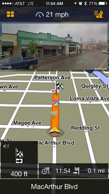
Navigon MobileNavigator: $33 for U.S. maps—including Alaska! It has lane assistance, street-view photos of destinations, spoken speed warnings and a map manager that lets you just download the areas you need, so you can save space on your phone. This is the app I use the most.
Garmin StreetPilot:$50 for U.S. maps, or $60 for North America—you need the North America package to get Alaska. Has integrated Google Local search, lane assistance and photo-realistic junction views, plus an integrated red light and speed camera database and community-generated alerts. A lot like a Garmin GPS in your phone.
Motion-X Drive: The cheapest option, at just 99¢—but you’ll have to buy a Live Voice Guidance package after the initial thirty day trial if you want spoken directions, which ranges from $3 for 30 days to $9 a year for an auto-renewing subscription. Drive has a pretty comprehensive feature set, with visual lane assistance, live local speed limits and pre-loading of maps for offline use.
CoPilot Premium USA: A good value at $8, this app for iPhone and Android includes USA maps (with free quarterly updates, apparently forever) and it includes voice guidance and a year of traffic service free with purchase—after that it’s $10 a year.
Mounting and Protection
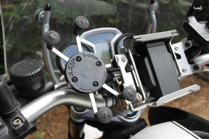
You don’t want your phone popping off your bike and disappearing into a canyon, right? Secure mounting is critical. The most universal solution I’ve found is RAM’s X-Grip ($52.79 with all mounting hardware or $26.78 for just the mount from Adventure Designs in Hayward, CA. It’s easy to use and surprisingly secure—I know lots of people who use these mounts and haven’t heard a single story of phones bailing out. Plus, since it’s a RAM mount, it’s very flexible—you can put your phone just about anywhere with a combination of arms and balls.
You’ll also want to keep your phone safe from flying objects (or becoming a flying object), unless it’s mounted right behind your windscreen. There are about as many phone case options as there are opinions on oil and tires, so pick one you like and go with it.
I’m currently using a Ronin G10 case from Element Case ($190). It’s constructed of machined aluminum, G10 (another name for Garolite, a tough plastic-like material that’s used for circuit boards) and carbon for a good level of protection and gearhead looks without the bulkiness that a lot of cases have.
Power
Navigation apps use a lot of juice—if you don’t wire up a power source for your phone you’ll be back to paper maps within a couple hours of riding.
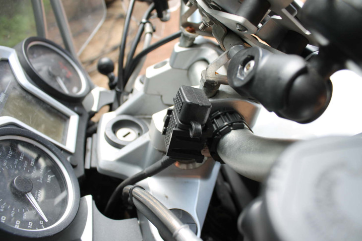
The simplest and most versatile solution is a USB port, but if you prefer a heavier-duty solution, Powerlet makes some industrial-strength connectors. I’ve used both, and prefer a USB port since it doesn’t require a specific cable—I can charge my phone, camera, or headset from the port with a basic USB cable, whereas the Powerlet ports require device-specific cables. I’m currently using a USB port made by 3BR Powersports ($45), mounted on my handlebars just to the left of the clamps—right under where my phone is mounted. It’s compact and has a weatherproof cap to keep things dry when it’s not in use.
It’s a trivial task to wire up a USB port directly to the battery on most bikes, but if you’re going to add other electronic accessories, consider using a hub of some sort. I installed a Fuzeblock FZ-1 ($84) under my seat so I can easily wire in other accessories, and I can also control which items have switched power and which are “always-on.”
Make sure you wire up your power source so the cable doesn’t interfere with anything important (like your brakes!) while riding. Even if it’s not in the way, a flapping cable can be distracting—so spend a couple minutes making this part of your installation right.
Headset
One of the best things about navigation apps (second only to not getting lost) is spoken directions. There are lots of options—here at MD we use an array of headsets from Cardo and Sena
If you just want to hear the sultry electronic voice of your phone on the cheap, it’s hard to beat the Sena SMH-5 at under $100 (MSRP $129), but both companies offer several options. I’ve been beating the hell out of a Sena SMH-10 ($209) for over two years now and it’s been very reliable, even if it lacks audiophile quality sound.
Putting it all together
Once you’ve gathered up your bits and bobs, you can be ready to roll in a couple hours.
- Choose an app and download it. Figure out how to use it over your morning coffee.
- Figure out where you want your phone and mount it accordingly.
- Wire up your power source so it’s easily and safely accessible.
- Install your headset.
- Choose a destination and ride.
If you decide to ride to Alaska or do an Iron Butt, you’ll probably want to invest in a “real” GPS. But most riders will find that a smartphone running a navigation app with downloadable maps is a functional and even cool solution.
A note about safety: we motorcyclists love to bitch about “idiot texting cagers” so don’t be stupid and try to navigate while riding. It’s really dumb—you’ll crash, probably hurt yourself, and also look like a moron. So don’t use gloves that work with your touchscreen so you’ll have to stop and take off your gloves, or use an app like the CoPilot that locks the controls when it senses movement—that will remove the temptation to try to nav n’ ride.
More information:
Apps
Mounting & Protection
Power
Headsets
Look for a huge selection of electronics accessories for motorcycles in the Aerostich catalog. Ask your order-taker about Aerostich’s price-matching, too.


I never get lost. People line up to tell me where to go…
Mount schmount. AM I the only one who uses velcro? Yeeks. So. Simple. Perhaps no profit margin by selling links to new gear sites.
you and your silly Velcro, who do you think you are…? Richard Dean Anderson…? 🙂
Of course there is always the fact that phone screens are notorious for not being readable in sunlight (though my Zumo 660 isn’t exactly easy to read in that environment either).
While *some* smartphones are ‘inexpensive’, the ones that people fawn over cost as much as a Zumo and will not survive long, high speeds trips over rough roads in rainy weather. Sure, you may have received a subsidy for your iPhone 5s, but if you need a new one before your entitlement comes up again it will cost you big time.
Sure, you can buy a cheap Android or Windows phone for your bike. But then you can also buy a cheap dedicated GPS for the same or less and either will do exactly what you need – but the cheap, dedicated GPS probably does navigation better since that is all it has to do.
As to those who commented about the need for GPS at all on board, I invite you to read my justification for buying my first consumer GPS back in 2003 as explained in my review of the Streetpilot; I already had a long history of involvement in vehicle tracking on a professional basis, but had never seen the benefit to having GPS on board until then:
http://www.epinions.com/…/pr…/content_147941396100
I currently use my Note3, the X-mount, a waterproof case, a USB power cable, my SENA bluetooth headset and an app named Waze. Seems to do the trick for me, but also have some other GPS apps loaded just in case. Voice navigation, traffic/hazard alerts, even radar traps and red light cameras are marked and announced via the bluetooth. Couldn’t ask for much more….
I can’t see doing this just yet. For about $100 I could buy a waterproof case, a mount, and a BMW-type adapter cord for my power outlet and use my present stand-alone Garmin Nuvi 1350. I only need GPS when looking for a motel when touring. I like the old AAA maps and get them laminated. And iI wear earplugs so I don’t want to use Bluetooth.
Another tip: most of the Android tablets have a built in GPS receiver. The I-phone ‘n I-pad don’t. You can buy a seperate GPS receiver which plugs into those devices. Google it.
Sorry, but iPhones have had GPS receivers since the first generation. Only the Wifi iPad does not come with one built in, the iPad with cell connection does and has since day one as well. If you want to know the truth check out the Apple site!
OVERKILL !!! Gadgets for gadgets sake !!
I just have a stereo bluetooth headset ($40) and listen to tunes and let the voice guidance tells me where to go every now and then from my Android phone. Simple, safe and relatively cheap.
Do it my way people.
I just use a Garmin Novi 40lm with the supplied suction mount on my speedometer(dr650)and a battery tender cigarette power outlet. Less than $100 total. It also is a lot more accurate for my speed. Yes it’s not water proof but then after 45 plus years of riding I’m not the hard core rider I used to be. I also use an adhesive tie down on the Garmin and twist tie to the clutch cable in case anything breaks loose.
The last time I tried to use the phone for navigation I tossed it in the map pocket and it over-heated within about 15 minutes.I’m still looking for a +2.00 bifocal strip for my helmet shield just so I can read it anyway.
This is lame. The only electronic accessory lashed to the handlebar of a MC should be a radar detector, and if it isn’t water proof, put a zip-loc on it. GPS navigation? Please.
What can we say? Some people used to say headlights were unnecessary, and they are if you don’t ride in the dark.
Good argument! GPS and headlight – totally the same thing!
Thanks, glad you see it.
Wow. Pretty strong comment. Why do you feel this way? Do you really think they aren’t useful? If that is what you think, then what is your take on why many people say that they are extremely useful and convenient? I mean, the great utility of having GPS on a motorcycle is so obvious to me, that I wonder what motivates such as the one you made. What about carrying maps on the bike, say, in a tankbag? Are maps okay? Are tankbags okay? If maps are okay, then isn’t it obvious that a GPS will be vastly more convenient?
why would you need a radar detector? They post speed limits and you have a speedometer. Just make sure the speedo matches the sign
re: “the fact that riders love to spend on ridiculously priced farkles”
yeah they do. God bless them, one and all. (Tiny Tim voice)
Nokia Lumia phone come preloaded with Here Maps / Here Drive which are Nokia’s excellent mapping and driving apps. They store all of the maps on the phone so a data connection is only required for traffic info. The maps are updated free for the life of the phone and maps are available for dozens of countries.
The Nokia Lumia 520 is currently selling for $50 without contract so it would be cheap way to pick up a phone to use as a dedicated GPS.
Sounds like a great setup—thanks for the tip, Jason!
I really hate cell phone GPS. A Garmin GPSMAP 60 is around $350, figure another $50 to $100 for maps if you don’t use one of the many free ones available, and does a wonderful job of letting you plan routes on your PC, set waypoints for spots you’d like to visit, follow tracks, etc. The phone is fine when I’m trying to find Chinese near my hotel, but for routing it’s not for me..
I’ve been using the Waze app for a few years now. Most of the time it works great here in Connecticut, but I was recently in California, driving from LA to San Francisco, and on certain sections of the Pacific Coast Highway, cell signal is spotty at best. One of these apps would certainly come in handy there.
You don’t need all those fancy gizmos…I just bring my wife with me on rides…she’s always giving me “directions” 🙂
Funny, I rode a 1990 Yamaha XT from Florida to Alaska in 1995, years before ‘long way round’ or ‘long way down’. I used Triple A (AAA)maps….never got lost….never needed a cell….common sense ain’t so common NO MORE.
Enjoy your farkles.
I’ll rely on tools, skills and experience.
+1… Never had a map “crash” or go dead on me. The Phone/app stuff is useful of course, but a good map is a GREAT way to go too.
I prefer a good old fashioned paper map stuck in the map pocket of my tank bag. Yes, I have to stop occasionally to read it but I’m not taking my eyes off the road to look at a screen. I also get to see some new places when I take a wrong turn due to forgetting what I just read on the map but that’s just part of the fun.
+2
I run a long trip (2-4,000 miles) every year, and the system that works for me is a map folded and stuffed in the tank bag map holder. Cell phone in Airplane mode while traveling, mainly just to save battery life since they suck the battery down looking for cell signals if there are none around.
Then, when decisions need to be made, or weather looks bad, the smartphone gets fired up to check out weather radar, check out stopping places or food, etc…
Best of both worlds! And the Maps have never run out of battery. They do get a bit worn with all the folding and refolding, but it’s just part of the fun, and most state rest areas have free maps near the borders.
Good article though… Always enjoy reading about the farkles!
It cracks me up when people turn matters of preference into quasi moral or comptence standards as in: using a GPS = no common sense. Because in 1995 B.C. people walked all over the place without no stinkin AAA maps. Matter of fact, they didn’t even use motorcycles to get around. They relied on flint knives, star navigation, and pure grit. People these days with their bikes, maps, and GPSeses are a disgrace to their bearskin wearing ancestors.
Let’s see: all the equipment you’ve installed totaled $613.79 not counting your iphone and contract. A Garmin Zumi goes for $559 or so plus a few bucks for a mount. I don’t see the upside. Oh, that’s right: you can make a call if you get lost.
Hey Marc—you certainly don’t have to use everything listed here. A USB port, mount, and (cheaper) case plus an app with downloadable maps will run less than $150—substantially less than a Zumo.
Surj – That’s just the way I look at things. Tech is your thing and not mine (e.g., I’m still riding a carburetted bike) and I understand that one doesn’t have to go all out to get basic functionality. Good effort and good article.
Thanks Marc! I have some carbureted bikes (and paper maps) too. 🙂
Really? Is this what us old map folding dogs have regressed to? Tell me it ain’t true….
true.
While I would like to encourage MD to do more articles of this type I have to wonder how this example is useful. I can do a search and find out what GPS Apps are available for my phone. What I would like is a review of the options. In your opinion, which app is best? Which is the best deal? Which one did you buy?
Same for the case, why a Element Case Ronin G10 over a Life Proof? Just bling or is there a reason to pay twice as much? These are the kind of things I’d like to see in a How To post. Listing what I can find in a web search doesn’t seem like a good use of the resources of good, ‘ol MD.
Finally, “haven’t heard a single story of phones bailing out”. You have now. I admit it was on my on my human powered bike but my phone defiantly bailed on a bumpy, high speed road decent. I like the mount, I have one of each of my motorcycles, but the RAM X-Grip mounts do fail when you hit the right situation.
Goose
Hey Goose—thanks for chiming in.
This is intended to be an overview to get folks started, with some examples based on a couple years of researching and messing around with this myself. A how-to with a comprehensive review of all available apps, cases, mounts, power options, etc would be pretty far into TL;DR territory.
On apps: I bought both Navigon and Motion-X. As noted above, Navigon is the one I use most.
On cases: I dig the Ronin for the Spyderco-esque combination of materials and relative compactness for level of protection. I’ve also bought and used Lifeproof, Otterbox and RAM cases, and made various mounts for each that heavily emphasized retention to avoid the phone bailout you experienced (sucks!). Ultimately those weren’t the right choices for me.
Also, I’d imagine that a review of just phone cases would be criticized as “not moto enough.” In this case (yuk yuk) I mentioned the Ronin because it’s what I’m using now. And you gotta admit, it does look cool.
I understand the balancing act, you’ll never please everybody but you have to try to entertain and inform the majority.
Thanks of the specific info.
Goose
if anybody’s looking for “moto enough” you may wanna consider Rokform. little known, Rokform is actually a sub-brand of Craig Erion and 2 Bros Racing. well actually it’s 1 brother, but you know what I’m saying.
i hear/tell he’s a motorcycle guy, so if you’re one who’s inclined to pay more than “lip service” to supporting the industry…? well here’s your chance.
correction: here’s YET ANOTHER chance on top of the long list of chances already available to you.
Norm, thanks for sharing that. I wasn’t familiar with Rokform and the mounting looks pretty good. I’ll have to check it out.
Surj, i commented below that MAgellan Roadmate (despite charging a lot and downloading a full base map to the phone) stops navigating if it loses cell signal. have you tried putting your phone in airplane mode to see if the navigon or motion-x keep guiding?
Hey Sam—I have not, but airplane mode turns off GPS too so that’s a no-go. (reference: http://support.apple.com/kb/ht1355)
I will say that I’ve used both extensively in the hills with zero cell coverage and been fine.
I’ve been using Magellan Roadmate for 3 years on my iPhone and iPad-Mini. Free updates for life. It loads the whole database so you don’t need a data connection; only a GPS signal. My iPad Mini is a wifi only unit. I use a Dual GPS antenna and connect it via bluetooth. If I hot spot the iPad to my iPhone I can also get data and utilize the traffic re-route feature. Otherwise you don’t need data.
you sure about about it not requiring a data connection? try putting your phone in airplane mode (to simulate being in an area with zero coverage) and see if Roadmate still works. it didn’t for me, which was incredibly frustrating – “why the hell did i drop $50 on your app and download a 1GB base map if you still have to ping the mothership, just like Apple/Google Maps?!?”
I have used Roadmate and Tom Tom software without a data connection (with the phone off) while using the Dual GPS antenna. Check it out
http://gps.dualav.com/explore-by-product/xgps150a
Magellan Roadmate is a decent iPhone app, but the others are probably cheaper/as good or better. I use a monoprice 12v > USB adaptor ($3.00) plugged into a marine grade 12v receptacle. It’s not waterproof though.
Oh, forgot to add, that’ _downloaded_ maps. No need for connectivity to use this function.
Pfffffffffft. Lots of options besides using yur I-phone (don’t have one, but…)
I use an Acer 7″ tablet with the app OSMAND+. It’s about $10 with access to every state and country. Curretnly, I have about 10 states plus Mexico and India loaded on the (accessory) 32 gig card. Works just like a GPS but with a 7″ screen, big enuff to see.
Plus, it’ll do wifi, Blue Tooth, camera, music, pretty much anything except phone. And, with wifi and Skype, who needs a phone. 😀
$100 from Amazon, plus cost of the app and a 32 gig card.
Just one more option…
I have been wondering about the tablet idea. I have a nexus 7 and 10 at home and have been thinking that I would like to use the nexus 7 as you described. Just curious, do you have any issues taking your hands off the bars to control it (change songs, remove pop-ups, etc)? Do you know of any “remotes” or a “mouse” that could be used to control the tablet?